Texas is not just a state on a map. It is a stretch of land so wide and varied that crossing it feels like passing through multiple regions in one journey. From the pine forests of the east to the dry desert landscapes of the west, from coastal highways near the Gulf to open ranch country in the Panhandle, the terrain changes dramatically mile after mile.
Many people underestimate the scale of Texas until they attempt to drive across it. The state covers more than 260,000 square miles, making it larger than many countries. That size alone turns a simple question into something more layered: how long does it really take to drive across Texas?
The answer depends on direction, route, traffic, weather, speed limits, and even how often you stop. A straight-line estimate rarely reflects real travel time. Looking closely at geography, highway networks, and realistic conditions gives a clearer picture of what to expect.
The True Size Of Texas And What That Means For Travel Time
East To West Distance Across Texas
Driving from the eastern border near Texarkana to the western edge near El Paso covers roughly 800 to 880 miles, depending on the specific starting and ending points. Interstate 20 and Interstate 10 are common routes used for this journey. Under ideal highway conditions, maintaining steady speeds with minimal stops, this trip typically takes between 12 and 14 hours.
However, real-world travel often extends beyond those estimates. Fuel stops, meal breaks, traffic slowdowns around major cities like Dallas or Midland, and construction zones add time. Long stretches in West Texas may appear open and empty, but wind conditions and wildlife crossings can also reduce speed.
An east-to-west drive across Texas is a full-day commitment at minimum. Many travelers choose to split it into two days to avoid fatigue.
North To South Distance Across Texas
Driving from the northern border near the Oklahoma line down to the southern tip near Brownsville or the Gulf Coast spans approximately 750 to 850 miles. Interstate 35 is a primary north-to-south corridor, running through major cities such as Dallas, Austin, and San Antonio.
Under steady highway speeds, this trip typically requires 11 to 13 hours. Urban congestion, especially around metropolitan areas, can extend travel time significantly during peak hours.
Seasonal traffic near coastal regions or border crossings can also influence overall duration. While slightly shorter than east-to-west routes in some cases, north-to-south travel still demands serious planning and endurance.
Factors That Influence Driving Time Across Texas
Urban Traffic And Metropolitan Bottlenecks
Texas contains several major metropolitan areas, including Dallas-Fort Worth, Houston, Austin, and San Antonio. Passing through any of these cities during rush hour can add one to two hours to a trip. Construction zones and lane expansions are common due to ongoing infrastructure growth.
Even when highways appear wide and well-maintained, traffic volume can slow progress dramatically. Timing travel to avoid peak commuting hours makes a noticeable difference. Early morning departures often reduce delays and allow smoother transitions through urban centers.
Travelers who expect uninterrupted highway flow may find themselves surprised by city congestion, especially on weekdays.
Weather Conditions And Seasonal Changes
Texas weather varies widely by region. East Texas may experience heavy rain and storms, while West Texas can face strong winds and dust storms. During summer months, extreme heat affects both vehicles and drivers.
Rain can slow traffic and increase stopping distances. High winds in open plains may reduce speed, particularly for larger vehicles or trucks. In rare winter conditions, ice in northern regions may temporarily disrupt travel.
Weather does not always stop travel completely, but it often slows progress. Monitoring forecasts before departure helps avoid unexpected delays.
Road Type And Speed Limit Variations
Texas highways are known for higher speed limits compared to many other states. Certain rural interstate sections allow speeds up to 75 or even 80 miles per hour. While this shortens travel time under safe conditions, actual average speed may be lower due to traffic or enforcement zones.
Secondary highways and rural roads often reduce speed limits significantly. Travelers taking scenic or less direct routes may add extra hours compared to interstate travel.
Average speed over long distances rarely matches posted maximum limits. Factoring realistic averages provides more accurate time estimates.
Realistic Time Estimates Based On Popular Routes
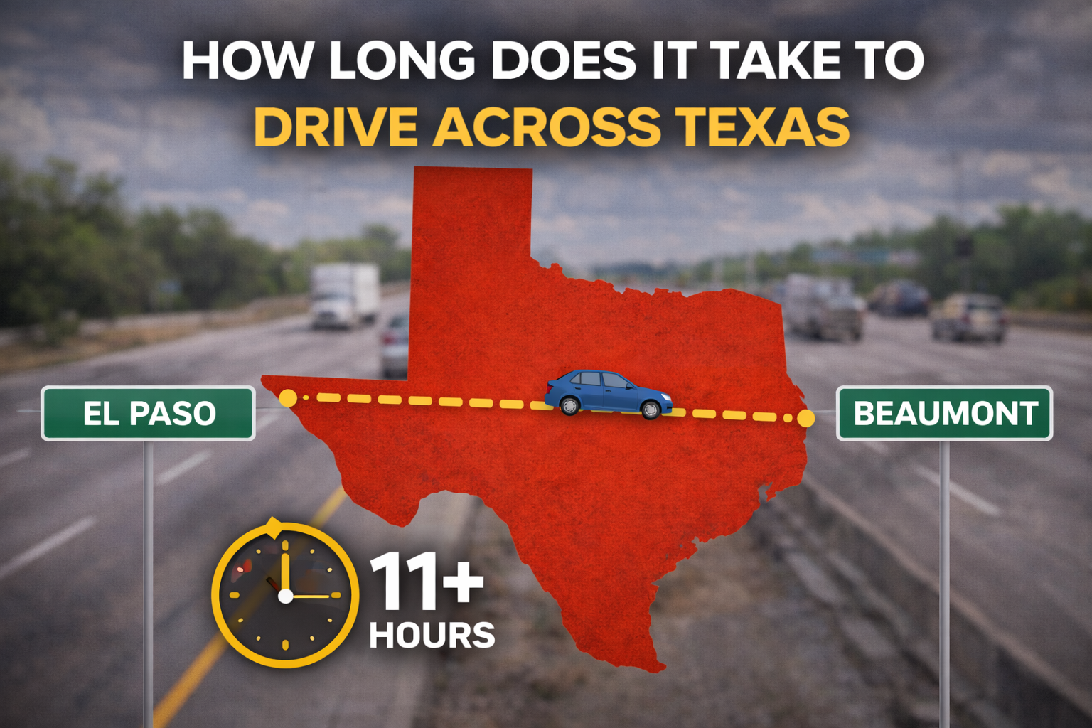
Interstate 10 From El Paso To Beaumont
Interstate 10 spans the southern portion of Texas and stretches approximately 880 miles across the state. Driving this route without extended stops typically takes 13 to 14 hours.
This route passes through cities such as San Antonio and Houston. Traffic density increases substantially as the highway approaches larger urban centers. West of San Antonio, the landscape becomes more open and speeds remain steady.
Travelers often divide this route into two segments due to distance and fatigue concerns.
Interstate 20 From West Texas To Dallas
Interstate 20 connects West Texas oil regions to major northern cities. A drive from the western border near El Paso to Dallas measures roughly 635 miles. Travel time usually falls between 9 and 11 hours depending on stops and traffic.
This route avoids southern coastal humidity but crosses wide open plains where services may be spaced farther apart. Planning fuel stops in advance is wise, particularly in rural stretches.
Interstate 35 From Oklahoma Border To South Texas
Interstate 35 cuts directly through the heart of Texas. From the Oklahoma line down to Laredo, the distance is approximately 500 to 600 miles. This drive typically requires 8 to 10 hours under favorable conditions.
Passing through Austin and San Antonio introduces heavier traffic patterns. Early departure times significantly improve flow through these areas.
Travel Planning And Endurance Considerations
Managing Driver Fatigue Over Long Distances
Driving across Texas in one stretch can be physically demanding. Even experienced drivers experience reduced focus after extended hours behind the wheel. Fatigue increases reaction time and decreases alertness.
Breaking the trip into manageable segments improves safety and comfort. A 12-hour drive may realistically extend to 14 or 15 hours once rest stops are included.
Hydration, rest breaks, and switching drivers when possible make the journey more sustainable.
Fuel Planning Across Wide Rural Areas
Although Texas has frequent service stations along interstates, rural western sections may have longer gaps between fuel stops. Vehicles with smaller fuel tanks should monitor levels carefully.
Running low on fuel in remote stretches adds unnecessary stress. Planning refueling intervals every 250 to 300 miles maintains peace of mind.
Modern navigation systems help identify service areas, but confirming availability before long stretches is advisable.
Breaking The Trip Into Practical Segments
One Day Versus Two Day Crossing
Attempting to drive across Texas in one day is possible but demanding. A single 12- to 14-hour stretch leaves little room for unexpected delays.
Dividing the trip into two days allows time to rest, eat comfortably, and explore small towns along the way. Overnight stops in cities like San Antonio, Midland, or Abilene create manageable segments.
Splitting the journey often results in a more relaxed schedule and reduced physical strain.
Scenic Routes Versus Direct Highways
Choosing scenic highways instead of interstates adds both charm and travel time. Secondary roads pass through small towns and countryside landscapes that differ from major highways.
While scenic routes may increase travel time by one to three hours, they provide variety and cultural stops. Travelers seeking efficiency typically stay on interstates, while those seeking exploration may accept longer timelines.
Bottom Line
Driving across Texas is not a quick endeavor. East-to-west routes typically require 12 to 14 hours under steady conditions, while north-to-south travel often ranges from 10 to 13 hours depending on distance and traffic. Real-world travel includes rest breaks, urban congestion, and weather considerations that extend those estimates.
The size of Texas demands planning. Factoring fuel stops, fatigue management, and traffic patterns produces more accurate expectations than simple mileage calculations. Whether completed in a single long day or divided into segments, crossing Texas highlights the state’s vast scale and regional diversity.
Preparing for distance rather than assuming speed makes the journey smoother and far more manageable.